Shenandoah National Park stretches along the crest of the Blue Ridge Mountains in Virginia, and one road runs its entire length: Skyline Drive. For 105 miles it follows the ridgeline with the Shenandoah Valley on one side and the Piedmont on the other, which makes the park one of the easiest in the country to enjoy from behind the wheel.
This guide covers how to drive Skyline Drive, which overlooks and short walks to prioritize, when the fall colors arrive and how the road continues south as the Blue Ridge Parkway toward the Smokies.
Shenandoah National Park at a glance
| Item | Details |
|---|---|
| Location | Blue Ridge Mountains, Virginia |
| Established | December 26, 1935 |
| Size | About 200,000 acres |
| Visits in 2025 | About 1.68 million |
| Entrance fee | $30 per private vehicle, valid 7 days |
| Park annual pass | $55 |
| Highest peak | Hawksbill Mountain, 4,051 feet |
Driving Skyline Drive
Skyline Drive is the only public road through the park. It has four entrances, and the mileposts along the west side count from north to south:
- Front Royal, mile 0, the northern end
- Thornton Gap, mile 31.5
- Swift Run Gap, mile 65.5
- Rockfish Gap, mile 104.6, the southern end
The speed limit is 35 mph in most places, so the full length takes about three hours on a clear day without stops. With overlooks and a walk or two, plan a full day, or split the drive over two days with a night in the middle of the park. Vehicles taller than 12 feet 8 inches cannot pass through Marys Rock Tunnel at mile 32.2.
The road is generally open around the clock, but it can close in bad weather, and it closes from dusk to dawn during part of the hunting season in late fall and early winter. Check the park’s alerts before an early or late drive.
Overlooks and short stops worth your time
There are 75 overlooks along Skyline Drive, so you will not stop at all of them. A few areas stand out:
- Skyland, around mile 41.7, the highest point on the drive at 3,680 feet, with lodging and sweeping valley views.
- Big Meadows, around mile 51, with a lodge, a campground and the Harry F. Byrd Visitor Center. Deer often graze in the open meadow at dusk.
- Dark Hollow Falls, from a trailhead at mile 50.7: a 70-foot cascade 0.7 miles below the road. It is the closest waterfall to the drive, and the walk back up is steeper than the walk down. Dogs are not allowed on this trail.
- Hawksbill Mountain, the park’s highest summit, reached by a short but steady climb from the drive.
Morning and late afternoon light is best at the westward-facing overlooks, when haze is lowest and shadows give the ridges depth.
Fall colors in Shenandoah
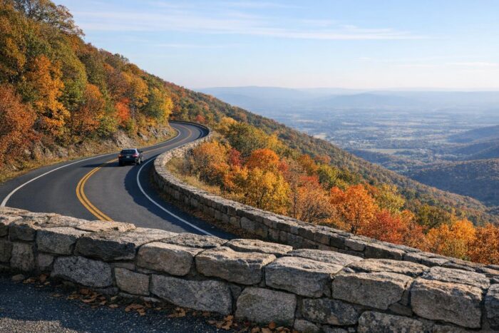
Fall brings some of the park’s biggest crowds, and October is when the hardwood forests along the ridge usually turn red, orange and gold. Because Skyline Drive runs along the crest, it sits above much of the valley, and the color often appears up high before it reaches the lowlands.
A few tips for a foliage trip:
- Drive on a weekday if you can. October weekends bring lines at the entrance stations and full parking at popular overlooks.
- Enter at a less busy entrance, such as Swift Run Gap or Rockfish Gap, rather than Front Royal, the closest to Washington, D.C.
- Book lodging and campsites well ahead.
The park plans to install automated entry stations at all four entrances in fall 2026, so expect changes in how you pay at the gate.
From Skyline Drive to the Blue Ridge Parkway
At Rockfish Gap, Skyline Drive meets US 250 near Interstate 64, and the same ridge road continues south as the Blue Ridge Parkway. The Parkway winds for 469 miles through Virginia and North Carolina and ends at the edge of Great Smoky Mountains National Park, near Cherokee. Driving both back to back is one of the classic Appalachian road trips: Shenandoah at one end, the Smokies at the other, and a week of mountain views between them.
Before you commit to the full route, check the Parkway’s daily road status page. Hurricane Helene caused heavy damage to the road in 2024, and some sections have been closed for repairs. Detours on nearby highways are usually possible, but they add time.
If this ridge trip is part of a bigger plan, our region-by-region guide to America’s top parks shows which other parks pair well with the East Coast mountains.
How much time to spend in Shenandoah
| Time | Suggested plan |
|---|---|
| Half a day | Enter at Thornton Gap, drive south to Big Meadows and back |
| 1 day | The full 105 miles with stops at Skyland, Big Meadows and Dark Hollow Falls |
| 2 days | Full drive plus a hike to Hawksbill and a sunset at a western overlook |
Shenandoah National Park FAQ
How long does it take to drive Skyline Drive?
About three hours for the full 105 miles without stops. Most visitors take a full day with overlooks and short walks.
How much is the entrance fee?
$30 per private vehicle, valid for seven consecutive days. A Shenandoah annual pass costs $55.
When is the best time to see fall colors?
October is usually the peak month. Weekdays are far less crowded than weekends.
Does Skyline Drive connect to the Blue Ridge Parkway?
Yes. At Rockfish Gap, the southern end of Skyline Drive, the road continues as the Blue Ridge Parkway toward the Great Smoky Mountains.