Death Valley National Park is the largest national park in the contiguous United States, at more than 3.4 million acres, and the hottest. It also holds the lowest point in North America. For a road trip, that means huge distances, few services and a short list of famous stops strung along two main roads.
Here is what to see, how to handle the heat and the fuel question, when to go, and how to link the park with Las Vegas or Joshua Tree.
Badwater Basin, the lowest point
Badwater Basin sits 282 feet below sea level, the lowest point in North America. From the parking area, a boardwalk and then a flat path lead onto white salt flats that stretch across the valley floor. Walk out a little way: the salt polygons get crisper the farther you go from the road. Look back at the mountains to the west for a sense of the depth.
Badwater lies south of Furnace Creek on Badwater Road, which also gives access to Artists Drive.
Artists Drive and Zabriskie Point
Artists Drive is a short scenic loop off Badwater Road that winds through colorful hills. Its main stop, Artists Palette, shows slopes streaked in pink, green and purple. The colors look best in the softer light of late afternoon.
Zabriskie Point, in the Amargosa Range just east of Furnace Creek, overlooks a maze of eroded badlands, with the sharp peak of Manly Beacon in the middle. The rock comes from the sediment of an ancient lake that dried up about 5 million years ago. It is a classic sunrise viewpoint and a short walk from its parking lot.
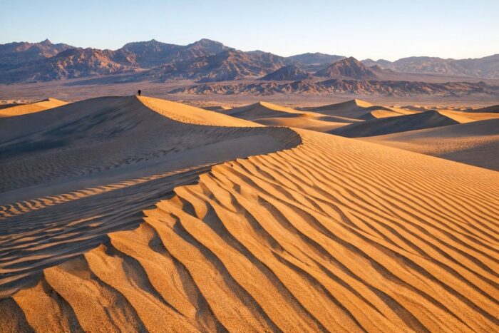
Other easy road stops: the Mesquite Flat sand dunes, reached from the paved road just east of Stovepipe Wells, and the Furnace Creek Visitor Center, with exhibits on the park’s geology and climate.
Heat and fuel: the two real dangers
Death Valley holds the record for the highest air temperature ever recorded: 134°F at Furnace Creek on July 10, 1913. Summer highs often pass 120°F in the shade, and nights can stay near 90°F.
- Water: the National Park Service recommends at least one gallon per person per day.
- Timing: avoid hiking in the valley and low elevations when it is hot. Summer travel, from April through mid-October, calls for extra water and supplies in the car.
- Fuel: there are three places to buy gas in the park, at Furnace Creek, Stovepipe Wells and Panamint Springs. Stovepipe Wells sells 87-octane gasoline only, no diesel. Fill up whenever you can.
- Electric vehicles: there are no rapid chargers in the park; the closest are in Beatty, Nevada, 43 miles from Furnace Creek.
- Signal: cell service is unreliable or absent on most roads, and GPS can send you down unsuitable tracks. Carry a paper map.
The park also warns that single-car rollovers on narrow, winding roads are its most dangerous hazard, more than the heat. Drive at the posted speed.
A one-day route through the park
- Sunrise at Zabriskie Point, a few minutes from Furnace Creek.
- Furnace Creek Visitor Center when it opens at 8 am, for road conditions and water advice.
- Drive south on Badwater Road to Badwater Basin, then loop back through Artists Drive.
- Midday break in the shade at Furnace Creek, with a full tank.
- Head west on CA 190 to the Mesquite Flat dunes for late afternoon and sunset near Stovepipe Wells.
Distances are longer than they look on the map, and many park roads are narrow and winding. Leave margin in the schedule rather than racing between stops.
Best season to visit Death Valley
Average highs at Furnace Creek reach 100°F in May and stay above it through September, peaking around 116°F in July. Winter and spring are the pleasant seasons, with average highs of 65°F in December and 82°F in March. Late October and November work well too: October still averages 93°F, but November drops to 77°F.
| Month | Average high | Average low |
|---|---|---|
| January | 67°F | 40°F |
| March | 82°F | 55°F |
| May | 100°F | 73°F |
| July | 116°F | 88°F |
| October | 93°F | 61°F |
| November | 77°F | 48°F |
Getting there from Las Vegas or Joshua Tree
From Las Vegas, two paved approaches enter from the east: CA 190 through Death Valley Junction, which leads straight to Furnace Creek, or State Route 374 from Beatty, Nevada, which brings you in near Stovepipe Wells and the dunes. A third eastern entrance, CA 178 from Shoshone, comes in at the south end near Badwater.
From the south, Death Valley pairs naturally with Joshua Tree National Park: both are Mojave Desert parks in California, and the CA 178 entrance from Shoshone is the logical way in when you drive north from the Joshua Tree area. Together they make a strong desert loop, and the two fit well into a longer tour of the national parks worth planning a whole trip around.
The entrance fee is $30 per private vehicle for seven days. The park does not accept cash; pay by card at a visitor center or fee machine, or online beforehand.
FAQ
How many days do you need in Death Valley?
One full day covers Badwater, Artists Drive, Zabriskie Point and the dunes. Two days let you catch both sunrise and sunset without rushing.
Is it safe to visit Death Valley in summer?
It can be done with care: stay near paved roads, keep the tank full, carry a gallon of water per person per day and avoid walking at low elevations in the heat.
Where can you get gas in Death Valley?
At Furnace Creek, Stovepipe Wells (gasoline only) and Panamint Springs.