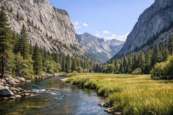
Kings Canyon National Park is the quieter half of the Sequoia and Kings Canyon pair, and for a road trip it comes down to two places: Grant Grove, a giant sequoia grove near the park entrance, and Cedar Grove, at the bottom of a deep glacial canyon reached by one of the most dramatic roads in California.
The link between them is the Kings Canyon Scenic Byway, a dead-end highway that is only open part of the year. This guide covers the drive, what to see at each end, when the road opens and closes, and how to combine Kings Canyon with Sequoia in one trip.
Kings Canyon National Park at a glance
| Fact | Detail |
|---|---|
| Established | March 4, 1940 |
| Area | About 462,000 acres |
| Main entrance | Big Stump, on CA-180 from Fresno (about 1¼ hours) |
| Grant Grove elevation | 6,600 feet |
| Cedar Grove elevation | 4,600 feet |
| Entrance fee | $35 per vehicle, 7 days, also valid in Sequoia |
Since 2026, non-US residents aged 16 and older also pay a $100 nonresident fee per person, unless they enter with an annual or America the Beautiful pass. There are no gas or EV charging stations in the park, so fill up before you leave the Central Valley.
Grant Grove and the General Grant Tree
Grant Grove is the first thing you reach after the Big Stump entrance, and it is open year-round, though the roads can be icy in winter. The Kings Canyon Visitor Center sits about three miles north of the entrance, with maps, restrooms and water.
The highlight is the General Grant Tree, the second-largest tree in the world by volume and known as the nation’s Christmas tree. A short paved loop leads around its base, past fallen giants you can walk through. Nearby, Panoramic Point offers a wide view over the high Sierra, but its narrow access road is often closed by snow in winter and is off limits to motor homes and trailers.
Driving the Kings Canyon Scenic Byway
The Kings Canyon Scenic Byway follows CA-180 for about 50 miles, from the Sierra foothills near Dunlap, past Grant Grove, down through Sequoia National Forest and into the canyon to Road’s End, where the highway literally stops. The section from Grant Grove to Cedar Grove is about 30 miles; allow 45 minutes to an hour without stops, and much longer with them.
Stops worth making on the way down:
- Junction View: an overlook above the meeting of the Middle Fork and South Fork of the Kings River.
- Yucca Point to Boyden Cave: the road is cut into nearly sheer canyon walls here, so drive slowly and use the pullouts.
- Canyon View: a classic look at the U-shaped glacial valley.
- Roaring River Falls: a short walk to a powerful waterfall in a granite chute.
- Zumwalt Meadow: an easy, flat trail around a meadow beneath towering cliffs.
- Road’s End: the ranger station and trailheads for longer hikes, including Mist Falls and the start of the Rae Lakes Loop for backpackers.
Since the road is a dead end, you come back the same way. Plan a full day for the round trip from Grant Grove, or stay a night in Cedar Grove, where a small lodge (21 rooms, open May to mid-October), a market and a visitor center are available in season.
When is the road to Cedar Grove open?
The highway from Grant Grove down to Cedar Grove is seasonal. The park says the road to Cedar Grove is typically open from May through early to mid-November, and in some years it opens in late April. Exact dates depend on snow and road conditions, so check the park’s road information before you go. Outside that window, Kings Canyon is limited to Grant Grove and the area around the entrance.
Cedar Grove’s lower elevation means warm days in summer and cool nights. Late spring brings full rivers and waterfalls, while early fall is quieter, with cooler hiking weather before the road closes.
Combining Kings Canyon with Sequoia
Kings Canyon and its neighbor, sequoia national park, share one entrance fee and are linked by the Generals Highway. From Grant Grove, drive south to Lodgepole in 45 minutes to an hour, then on to the General Sherman Tree and Giant Forest.
A good two- or three-day plan:
- Day 1: enter at Big Stump, see Grant Grove and the General Grant Tree, then catch sunset from Panoramic Point.
- Day 2: drive the Scenic Byway to Cedar Grove and Road’s End, with Zumwalt Meadow and Roaring River Falls on the way.
- Day 3: take the Generals Highway south to Giant Forest, then exit through the Ash Mountain entrance toward Three Rivers.
Entering from the north on CA-180 also suits larger vehicles, since the park recommends that route over the steep, narrow southern approach. In winter, the Generals Highway between Lodgepole and Grant Grove is not plowed from about the Friday after January 1 to the third Friday in March and often closes, so you may need to drive around through the foothills. Carry tire chains from fall through spring.
If Kings Canyon is one stop on a longer Western trip, our guide to the national parks most worth the drive helps you decide what to pair it with.
Kings Canyon National Park FAQ
Is Kings Canyon worth visiting if I have seen Sequoia?
Yes. Sequoia is about the big trees, while Kings Canyon adds a deep glacial canyon, rivers and waterfalls, plus the General Grant Tree.
Can you drive through Kings Canyon to the east side of the Sierra?
No. No road crosses the mountains through Sequoia or Kings Canyon. The Scenic Byway ends at Road’s End.
Is Kings Canyon open in winter?
Grant Grove stays open, but the road down to Cedar Grove closes from about mid-November until spring.
How long does the Kings Canyon Scenic Byway take?
About 45 minutes to an hour each way between Grant Grove and Cedar Grove, so plan a half day at minimum and a full day with stops and short hikes.