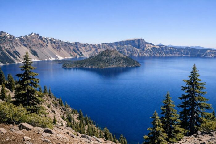
Crater Lake National Park in southern Oregon holds the deepest lake in the United States, a basin of startling blue water sitting inside the collapsed summit of an ancient volcano. For road trippers, the experience centers on one road: Rim Drive, which circles the caldera and stops at overlook after overlook.
The challenge is snow. Crater Lake is one of the snowiest inhabited places in the country, and the rim road is only fully open for a few months a year. Here is when to go, how to fit the park into a trip along I-5 or the coast, and what changes in 2026.
How Crater Lake formed
About 7,700 years ago, the volcano known as Mount Mazama erupted and collapsed, leaving a deep caldera. Over time, rain and snow filled it. The result is a lake nearly 2,000 feet deep, fed only by precipitation and famous for its clarity and color. Wizard Island, a cinder cone of about 316 acres, rises from the water near the western shore.
Rim Drive: the heart of crater lake national park
Rim Drive runs 33 miles around the caldera and is the only part of the park where you can see the lake from a car. It splits into two sections, West Rim Drive and East Rim Drive, with numerous pullouts along the way. Plan at least half a day to drive the full loop without rushing, and longer if you want to walk any of the short rim trails.
Rim Village, on the south side, is the main hub and the easiest place to see the lake in any season, since it is reached from the year-round entrances on Highway 62.
When the roads are open
Snow decides your itinerary here. Between 2004 and 2023, winter snow totals ranged from 16 to 56 feet, according to park records. The National Park Service gives this general pattern for opening and closing:
| Road | Typical opening | Typical closing |
|---|---|---|
| South and West Entrances (Hwy 62) to Rim Village | Open year-round | Open year-round |
| North Entrance Road and West Rim Drive | Between mid-May and late June | First major snowstorm or November 1 |
| East Rim Drive | Between mid-June and late July | First major snowstorm or November 1 |
Plowing usually starts on West Rim Drive in mid-April, and all roads are typically clear by mid-July. In recent years, roads closed as early as October 1 in some seasons. For the full Rim Drive, July through September is the safest window.
What changes in 2026: Cleetwood Cove is closed
The Cleetwood Cove Trail is the only legal and safe way down to the lake shore. The park is rehabilitating the trail and marina in a project that takes three summers, with construction expected to begin in early summer 2026. During that time, the trail, the shoreline and the Cleetwood parking lot are closed, and there are no public boat tours on the lake in 2026, 2027 or 2028. You can still see the lake from the many viewpoints along Rim Drive and from the park’s trails.
Fees
A standard pass is valid for seven days. A private vehicle costs $30 in summer (May 22 to October 31) and $20 in winter (November 1 to May 21). Motorcycles cost $25 in summer and $15 in winter, and visitors on foot or by bicycle pay $15. A Crater Lake annual pass costs $55, and the America the Beautiful pass is accepted.
Getting there from I-5 or the coast
Crater Lake lies inland in the Cascades, so it is always a detour, but a worthwhile one. The main approaches:
- From Medford (I-5, south): Highway 62 leads to the West Entrance, open year-round.
- From Klamath Falls: Highway 97 to Highway 62 and the South Entrance, also open year-round.
- From Roseburg (I-5, north): Highway 138 east to the North Entrance when it is open; otherwise continue on Highway 230 to Highway 62 and the West Entrance.
- From Eugene or Portland: leave I-5 south of Eugene on Highway 58, then Highway 97, and enter from the north or south depending on the season.
Coming from the coast, the logical route is from Crescent City in Northern California, where redwood national park sits on US-101. From there, US-199 heads inland to Grants Pass on I-5, and Medford and Highway 62 lead up to the park. That makes Crater Lake an easy add-on to a redwoods trip: giant trees one day, a volcanic lake the next.
How much time to spend
Half a day is enough for Rim Village and part of the West Rim. A full day lets you complete the loop when both sections are open. If you are building a longer itinerary through the West, our picks for the parks most worth planning a road trip around show how Crater Lake fits with its neighbors in the Pacific Northwest and California.
Crater Lake National Park FAQ
Can you visit Crater Lake in winter?
Yes. The South and West Entrances on Highway 62 stay open year-round, and you can usually see the lake from Rim Village. Rim Drive and the North Entrance Road are closed to cars in winter.
Can you swim in Crater Lake in 2026?
Not in practice. The only route to the shore, the Cleetwood Cove Trail, is closed for rehabilitation through the 2028 summer season.
How long does it take to drive Rim Drive?
The 33-mile loop takes a few hours with stops. Check that both the West and East sections are open before you plan the full circle.
How deep is Crater Lake?
It is the deepest lake in the United States, at nearly 2,000 feet.